Long Lake Provincial Park Association (LLPPA) is pleased to announce that we have a new map of the Lakeview Trail region of the park that is managed by LLPPA. The map has been prepared by cartographer Darren Talbot who lives in Spryfield. Once we have raised sufficient funds and have sorted out the logistics, we plan to place copies of the map at strategic points on the trail. In the meantime, it may help park users to find their way around by looking at the maps posted here. Various parts of the map are shown below.
The whole map

The inset
LLPPA manages a relatively small section of Long Lake Provincial Park under a formal agreement with the province. The association advocates for the whole park but has no direct management responsibility in other parts of the park. The inset shows the whole park and the section managed by LLPPA.

Witherod Lake Loop
Most people walk the trail around Witherod Lake. Newcomers can find this section of the trail confusing. A map is very helpful in this regard.

Detail of the main parking lot on Dunbrack
The map contains a lot of fine detail. Here is the section that includes the main parking lot on Dunbrack Street. Notice that “You are here” is where this version of the map will be placed when it is created as a sign.

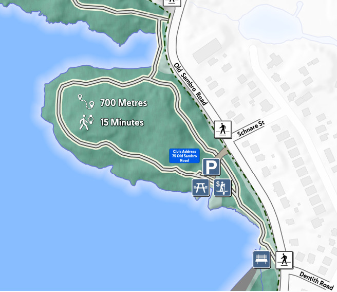
The boat launch site on Old Sambro
The section of the map showing the trail associated with the boat-launch parking lot on Old Sambro Road provides additional details.
The title, meaning of symbols, and credit
The title section of the map includes explanations of the symbols. Credit for the map’s designer is tucked in the lower corner of the map.


[…] activities in the next few years. We will expand our interests to the provincial park as a whole (see map here), improve our connections with related community groups, put more effort into gathering information […]