Long Lake and Chain Lakes
Much of Long Lake Provincial Park lies in the watershed of McIntosh Run. “The Run” as it is sometimes called flows south from Long Lake and enters the Atlantic Ocean at Herring Cove.
A watershed is all of the area from which a river or stream obtains water from precipitation. Alternative names for ‘watershed’ are ‘drainage basin’ and ‘catchment’. These three terms have the same basic meaning.
Watersheds can be altered by civil engineering practices and the watershed of Long Lake is a good example of this. The map below was prepared by Professor Ogden of Dalhousie University in 1983. I have added colors to make the various watersheds clearer. Region F is the McIntosh Run watershed and region E is the watershed of Bayers Lake, the Chain Lakes and Chocolate Lake.

This map is no longer correct because the drainage basins were altered when the Bayers Lake Business Park was developed. The outflow from Bayers Lake was directed away from the Chain Lakes to Long Lake by construction of a channel.
Better Mapping
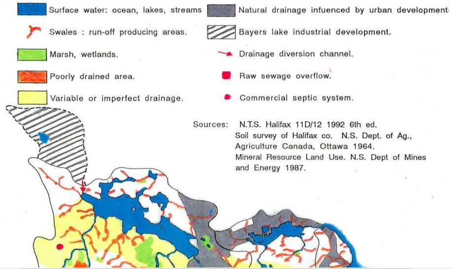
Mapping methods have improved progressively since Professor Ogden made his map. The map below was prepared in 1994 by Henri Steeghs, a student in the Environmental Planning program at Nova Scotia College of Art and Design (NSCAD). Notice that the northwest portion of these two maps differ.

The report by Steeghs is publicly available.
Watershed maps can be improved by modern methods, notably by using LIDAR technology, but no publicly available LIDAR map of the Long-Lake-McIntosh-Run watershed has yet been prepared. Long Lake Provincial Park Association is hoping to obtain better mapping in the future.
Acid Rock Drainage
Steeghs described the pollution (known as acid rock drainage) that entered Long Lake as a result of the diversion of water from the growing Bayers Lake Business Park. Hydrological engineering of a wetland south of Bayers Lake has mitigated this ongoing pollution to some extent.
The following is part of one of Henri Steeghs maps showing the area around Bayers Lake that collects water and directs it via an engineered wetland and a channel to Long Lake.
Halifax water supply
Long Lake is an artificial lake created by a dam. Together with the Chain Lakes it was the main source of water for Halifax from the mid 1850s until 1974. As demand for water in the growing city increased from the 19th to 20th Centuries, other lakes were added to the water supply system. Spruce Hill Lake was the most significant of these because it was at a higher elevation than Long Lake and provided greater pressure for the gravity-fed system. Spruce Hill Lake also lies in Long Lake Provincial Park.


Leave a Reply